Pre-registration for Paris-Brest-Paris 2027 opened on 31 October, and the route isn't out yet. The organisers' route page lists the controls and says "The detailed route of Paris-Brest-Paris Randonneurs 2027 will be communicated at a later date", with the GPX tracks "coming soon".
So we worked out where it probably goes, from what has been published, and checked our line against the organisers' own numbers.
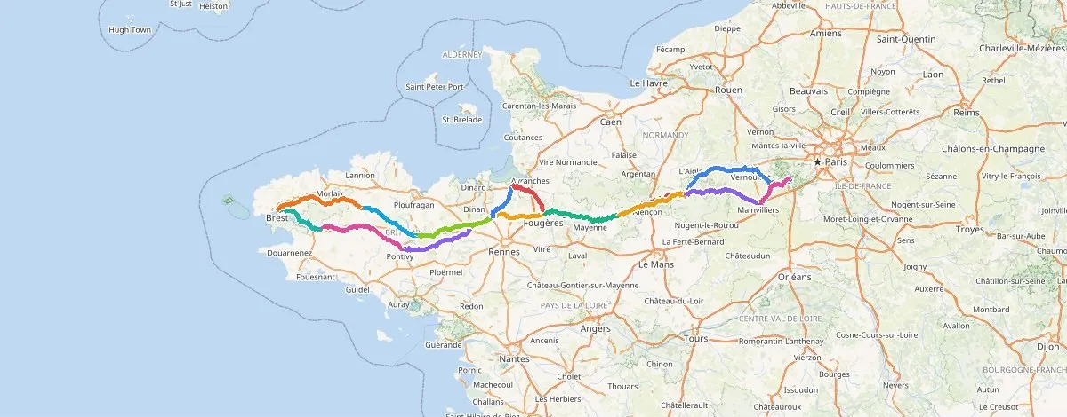
What the organisers have published
The route has 16 stages, each ending at a control: Mortagne-au-Perche, Villaines-la-Juhel, Fougères, Tinténiac, Pontivy, Pleyben and Brest on the way out, then Callac, Loudéac, Tinténiac, Roz-sur-Couesnon, Fougères, Villaines-la-Juhel, Mortagne-au-Perche, Chartres and back to Rambouillet.
Three distances are given: Mortagne-au-Perche at 119 km with 1,150 m of climbing, Brest at 590 km, and the finish at 1,220 km. The rest of the stage table is blank for now.
There's a shape too. The way out and the way back use different roads over most of the route, Brittany is ridden as a loop, the return passes close to Mont-Saint-Michel, and it's all on roads open to traffic.
Five lines between the same controls
We routed every stage from control to control in each of the planner's five route styles, then added them up.
| Route style | Reaching Brest | Brest back to Rambouillet | Whole route |
|---|---|---|---|
| Shortest | 551 km | 590 km | 1,142 km |
| Fastest | 555 km | 598 km | 1,153 km |
| Balanced | 634 km | 610 km | 1,244 km |
| Min climbing | 681 km | 647 km | 1,328 km |
| Quiet | 698 km | 666 km | 1,364 km |
| Our estimate | 593 km | 612 km | 1,206 km |
| The organisers | 590 km | 630 km | 1,220 km |
None of the five styles fits on its own. Shortest reaches Brest 39 km before the organisers' 590, so their way out isn't the most direct line. Balanced is within 24 km over the whole route but reaches Brest 44 km late.
Why Balanced runs long
Balanced prefers low-stress roads, and where there's a car-free path going the right way it takes it: 212 km of them over the whole route. The biggest is between Tinténiac and Pontivy, where it spends 84 km on car-free path and rides 142 km against 100 km on the direct road. Between Mortagne-au-Perche and Villaines-la-Juhel it takes 33 km of path each way.
The organisers' route is on roads open to traffic, with thousands of riders following arrows. So for our estimate we kept Balanced everywhere except on the three stages where a third or more of its line is car-free path (Mortagne-au-Perche to Villaines-la-Juhel both ways, and Tinténiac to Pontivy). There we took the direct road.
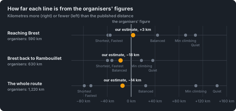
That lands Brest at 593 km, 3 km from the published 590, and the whole route at 1,206 km, 14 km under 1,220.
Our estimate, stage by stage
| Stage | To | km | Total | Climbing |
|---|---|---|---|---|
| 1 | Mortagne-au-Perche | 131 | 131 | 819 m |
| 2 | Villaines-la-Juhel | 73 | 204 | 671 m |
| 3 | Fougères | 81 | 285 | 748 m |
| 4 | Tinténiac | 54 | 339 | 383 m |
| 5 | Pontivy | 100 | 439 | 916 m |
| 6 | Pleyben | 98 | 536 | 996 m |
| 7 | Brest | 57 | 593 | 828 m |
| 8 | Callac | 98 | 691 | 1,200 m |
| 9 | Loudéac | 68 | 760 | 828 m |
| 10 | Tinténiac | 77 | 837 | 774 m |
| 11 | Roz-sur-Couesnon | 42 | 879 | 255 m |
| 12 | Fougères | 47 | 925 | 361 m |
| 13 | Villaines-la-Juhel | 80 | 1,006 | 820 m |
| 14 | Mortagne-au-Perche | 74 | 1,079 | 731 m |
| 15 | Chartres | 81 | 1,161 | 583 m |
| 16 | Rambouillet | 45 | 1,206 | 245 m |
That's 11,158 m of climbing in all. The estimate is in TourKit as a tour: Paris-Brest-Paris 2027, estimated from the published controls. Open it to see each stage on the map, or, with a free account, download it as one GPX for the whole route or a GPX for each stage.
What the gaps tell us
The way back is 18 km short. On the return the route passes Fougères, Villaines-la-Juhel and Mortagne-au-Perche again, and our line rides the same roads back between them. The organisers say the way back uses different roads over most of the route. A second road between the same two towns is usually longer than the first choice, which fits a return that's longer than ours.
The first stage is the clearest miss. The organisers give 119 km and 1,150 m to Mortagne-au-Perche. Our line is 131 km and 819 m, and none of the five lines we routed climbs more than 957 m on that stage. So the official first stage is shorter and hillier than anything a router picks between those two towns, which suggests it heads through the hills of the Perche on purpose.
The control sites will move things a little. We routed between town centres (Roz-sur-Couesnon in the village, on the Mont-Saint-Michel bay). The real controls are at particular halls and schools, a few kilometres either way.
When the route is out
When the organisers publish their GPX, we'll put our estimate next to it and show how close it got, stage by stage. Until then this is a planning estimate, not a route to ride: the event requires the official route.
For what 1,220 km and 90 hours mean for different riders, see 1,220 km, 90 hours. Where does the time go?.
How we worked it out. Each stage routed control to control in TourKit's planner on its road profile, in its five route styles, on 15 November 2026. Distances are the router's. Climbing is the ground's height under the saved line, read the way an altimeter counts it, and the organisers may measure it differently. The estimate is Balanced, except on the three stages where a third or more of Balanced's line is car-free path, which take the Fastest line. It is our estimate, not the official route.
Paris-Brest-Paris is organised by the Audax Club Parisien, and TourKit has no connection with it.